Why a Hillside Looks Different from Above
Why a hillside looks different from above: understand how overhead contours, slope direction and light reveal ridges, hollows and hidden changes in relief.
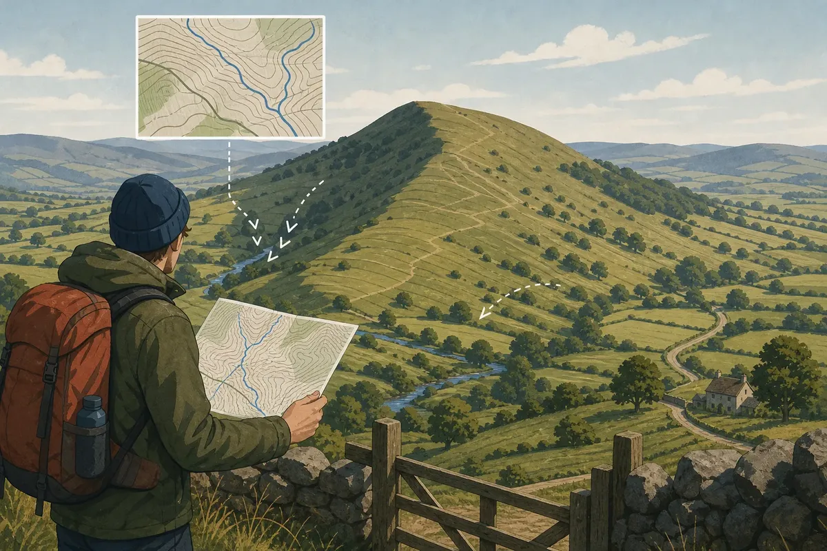
Why a hillside looks different from above is easiest to understand when you compare its map with the view from a ridge or across a valley. From overhead, contour lines reveal where ground rises, falls and folds; from the path, the same shapes are partly hidden by the slope in front of you. The difference is not a contradiction: each viewpoint exposes some features and conceals others.
What does an overhead view reveal?
A map gives a plan view, as if you were looking down on the land. Its contour lines join points of equal height, so their spacing and curves describe relief without showing a literal outline of the hillside. Close contours indicate a steeper slope; more widely spaced contours indicate gentler ground.
From above, a long ridge may appear as a curving line of higher ground between lower areas. A hollow shows as a fold in the surrounding contours, even if the ground-level view makes it look like a simple dip. Maps simplify small folds, and their contour interval and scale affect how much detail is shown, so check the legend before interpreting subtle shapes.
Shading on a map can make relief easier to picture, but it is an aid rather than a height measurement. Read it alongside the contours, mapped streams and other recognisable features instead of treating a dark patch as proof of a steep face.
How do contour bends distinguish a valley from a spur?
First orient the map so its north arrow, roads and streams match the landscape around you. Then find the lower ground: it may be a mapped stream, a valley floor or a clearly identifiable dip between slopes. This gives you a reference for reading each contour bend rather than guessing from the line’s shape alone.
Where contours cross a valley, their V-shaped bends point uphill, towards higher ground. In a stream valley, that means the tips of the Vs point upstream; the stream itself runs the other way, downhill. Where contours cross a spur, their bends point downhill, towards lower ground. A spur is a tongue of higher ground extending out from a slope, with lower ground on either side.
For a concrete reading, trace one contour as it crosses a mapped stream valley: follow its V to the point, then check that the point lies towards higher contours. For a spur, follow the bend away from the main slope and check that its point leads towards lower contours. These relationships stay the same when you rotate the map; they do not depend on which way you are facing.
Why can the view from a hillside mislead?
From the foot of a slope, the near face can hide the ground beyond it. Trees, hedges, walls and buildings may obscure changes in shape, while a distant skyline can make a rounded shoulder look like a sharp crest. From an offset position, such as a safe public viewpoint across the valley, the hidden side may become visible.
Light changes the appearance too. A ridge may cast a clear shadow that sharpens its outline, while shade can flatten a hollow or hide a break in slope. Separate these visual effects from the landform itself by comparing the contours and, if the route allows, looking again from a different direction.
How can you compare a map and a hillside?
Use a few recognisable features to connect the plan view with the ground. A road bend, stream junction, gate or ridge line can help you confirm where you are and which way the map should face. Then describe the broad shape before trying to name smaller folds.
- Check the map’s north arrow and match a mapped road or stream to the one you can see; if they do not align, reorient the map before interpreting the contours.
- Check the contour interval in the legend; if it is unfamiliar, avoid judging exact height differences and use the contour pattern only for the broad shape.
- Trace several neighbouring contours across a slope; if they bunch together, read that section as steeper, and if they spread apart, read it as gentler.
- Locate a valley floor or mapped stream; if contour tips point uphill towards it, read the bends as valley crossings, and if a bend projects towards lower ground, consider a spur.
- Check whether trees, a hedge or a building blocks the view; if it hides the slope, compare from another safe public viewpoint rather than filling in the unseen shape.
- Notice whether the face is in sun or shadow; if the outline is unclear, rely more on the contour pattern and leave uncertain details unnamed.
Say you are on a public path below a rounded hill. Your starting notes record a stream on the left of the view, a lane behind you and contours on the map that are close together on the hill’s near face but farther apart on its right-hand side. You turn the map until the stream and lane match their positions, then follow the public path to a gate across the valley and look back. From there, the expected observation is that the hill’s right-hand shoulder is less steep than the near face, while the stream-side contour bends point uphill. The resulting reading is a gentler shoulder beside a steeper face, with the stream valley identified by its uphill-pointing contour tips; if the landmarks fail to align, the map orientation remains unresolved and the shape should not be named yet.
What questions help when reading a hillside from above?
How do I tell a spur from a valley on a map?
At a valley crossing, contour bends point uphill; at a spur, they point downhill. Identify the higher and lower ground first, then check the bend against nearby contours or a mapped stream.
Why do valley contour tips point upstream?
A stream valley rises towards its source and descends downstream. The contour’s V points towards that higher ground, so it points upstream where a stream is shown.
Can I read contours without knowing the contour interval?
You can compare the broad shape and relative steepness, but you should not infer exact height differences without the interval. Check the map legend before making a more precise interpretation.
What if the hillside does not match the map?
Check the map’s orientation and confirm your position using a road, stream or other clear landmark. If the mismatch remains, account for hidden ground and map generalisation, and keep the uncertain feature undescribed rather than forcing a match.
What is not worth the effort?
Trying to name every crease from one distant view rarely helps. Nor is it useful to trace each contour before you have matched the map to the surrounding landscape. Start with the broad ridge, valley, spur or shoulder, and refine the description only when another viewpoint supports it.
Why a hillside looks different from above comes down to the gap between a plan view and a view from the ground. Contours show how high ground folds around lower ground, while your position, obstructions and the light determine what you can see. If you keep the map oriented and follow the contour bends against higher and lower ground, the map becomes a clearer guide to the shape in front of you.
Along the same path
High Wisps or Low Grey: Reading Cloud Shapes
Reading cloud shapes helps you describe the sky clearly, distinguish high wisps from grey layers and…
The Hedge That Became a Boundary
Learn how hedgerows became boundaries and read their banks, trees and gaps for clues to the…