The Hedge That Became a Boundary
Learn how hedgerows became boundaries and read their banks, trees and gaps for clues to the different land uses that shaped a countryside route.
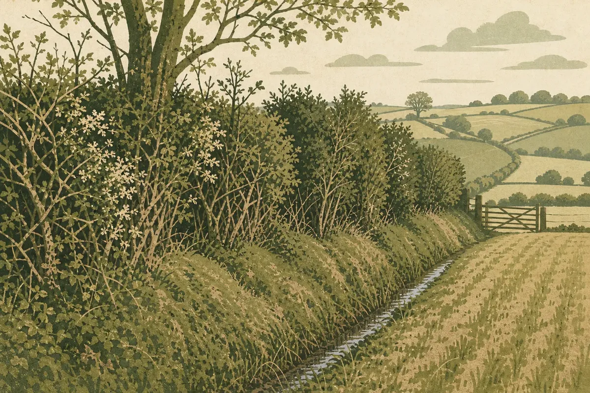
Why does one hedge stand on a raised bank while another is a narrow line of thorn trees? Hedgerow history is written in those differences: a hedge could mark a field edge, enclose grazing, divide ownership or persist after the work that created it had changed. The line on the map may look simple; the living boundary has a more particular story.
Why were hedges used as boundaries?
A hedge made a boundary visible and useful. Dense shrubs could slow livestock, mark the division between holdings and offer shelter, while a ditch or bank beside them strengthened the barrier. Unlike a fence that served one immediate purpose, a planted or laid hedge could also provide fuel, browse, small timber and habitat.
Its function depended on the place. A boundary between fields used for crops might be kept narrow enough to manage, whereas a line enclosing animals could be thicker and harder to pass. In some districts, hedges were planted; elsewhere, shrubs already growing along a bank or ditch were encouraged and maintained. The result was not one standard design, but a range of local solutions.
Boundaries also made land easier to organise. They could mark where a tenant’s responsibility began, separate a farm’s fields from common ground, or divide a larger area into workable parcels. A hedge may therefore outlast the particular arrangement of land that first gave it meaning.
What can the shape of a hedge tell you?
Start with the ground beneath the vegetation. A raised bank, a ditch, a wall or a simple strip of shrubs each suggests a different way of forming or maintaining the edge, but none proves a single history on its own. The clues gain meaning when read together: hedge height, tree spacing, nearby field shapes and the route’s position in the landscape.
A bank can indicate that soil was moved to make a more substantial boundary, or that repeated upkeep gradually altered the ground. If a ditch runs beside it, note which side the bank occupies, but avoid turning that detail into a firm ownership claim. Local practice, later repairs and changes to drainage can all complicate the pattern.
Look, too, at how the line meets the land around it. A hedge running in a long, regular stretch between similarly shaped fields may relate to a planned division. A crooked line following a stream or contour may instead reflect older limits, practical access or the shape of the ground. The line is evidence of decisions, not a label that identifies them by itself.
Do species reveal when a hedge was made?
Plants can offer clues, but a list of species is not a date. Hawthorn, blackthorn, hazel and field maple may occur in hedges of different ages, and a boundary can acquire new plants as birds disperse seed or as people replant gaps. A mixed hedge may reflect local abundance, deliberate choices or years of change.
One useful observation is the range and distribution of woody plants along a stretch. A hedge with several native shrub species, varied in age and woven through old trees, has a different character from a uniform line of recently planted whips. Still, an old-looking species mix does not establish when the boundary was first laid out; later planting may have altered it.
Also notice management. A laid hedge has stems bent and interwoven to form a dense barrier; a clipped hedge has a more regular outline; an unmanaged line may have grown into trees. These forms can reveal how people have wanted the boundary to work at different times. They are not a simple calendar: a hedge may be cut, neglected and laid again over generations.
How does a hedge reflect changing land use?
When fields are enlarged or farming practices shift, a hedge can be removed, allowed to grow tall, or left as a remnant between larger units. A surviving line may no longer contain livestock or define a working parcel, yet it can still divide the view and connect patches of habitat. Its present function may differ from its original one.
Old maps and aerial photographs can help distinguish a long-standing line from a more recent planting, especially when compared with what is visible on the ground. Parish maps, estate plans and historic Ordnance Survey sheets may show boundaries that have since disappeared or changed course. Treat each map as a record made for a particular purpose: a line may be omitted, simplified or drawn imprecisely.
The surrounding pattern matters as much as the hedge itself. Small, irregular fields enclosed by many boundaries suggest a different history from broad, open fields separated by sparse lines. Neither pattern has a single explanation everywhere. Soil, ownership, enclosure, farming choices and later consolidation may all have contributed.
What should you look for along a country lane?
Choose a stretch that can be observed safely from a public path, without stepping into a road or crossing a boundary. Look at the hedge as a structure rather than just a row of leaves: its base, its top, the trees within it and the way it joins other landscape features.
- Ground form: Is there a bank, ditch, stonework or level verge? Note how the features relate without assuming who owned either side.
- Plant variety: Are there several shrub types, or does one species dominate? Record what you can identify and leave uncertain plants unnamed.
- Management: Is the line clipped, laid, gappy or grown into a row of trees? These conditions may reflect different needs or upkeep.
- Field shape: Do boundaries form a regular pattern, follow a stream, or turn around a slope? Compare the hedge with the fields nearby.
- Connections: Does the line meet a woodland edge, another hedge, a lane or a watercourse? Its position can help explain how it functions in the wider landscape.
Say you are walking beside a narrow field with a raised bank, a shallow ditch and a mixed hedge that bends around a stream. You might note that the boundary combines a substantial earthwork with a natural feature, then compare it with a straighter hedge on the next field. The expected result is not a definitive date, but a clearer account of how each line relates to its setting and may have served different needs.
It is not worth trying to identify every shrub or infer the original owner from one feature. A short, careful description is more useful than a confident story built on a single clue.
How can maps help without settling the story?
A current map shows where a boundary lies now; an older map may show whether it existed earlier, shifted or vanished. Comparing editions can be especially revealing where roads, streams and field corners provide stable reference points. If the line appears on successive maps, that supports the idea of continuity, though it cannot tell you every reason for its survival.
Look for changes in the surrounding parcel pattern as well as the hedge itself. A boundary that persists while neighbouring fields merge may have become a remnant rather than an active division. A line absent from an older map may have been planted later, but it could also have been left out because the map was not intended to record every field edge.
For a more grounded reading, pair map comparison with visible clues: earthworks, tree form, species variety and the shape of nearby fields. Hedgerow history becomes more legible when no single source is asked to answer everything.
What questions do readers ask about hedgerow history?
Can a hedge be older than the fields around it?
Yes, a boundary may pre-date the current field pattern, or an older line may have been reused when fields were rearranged. Maps and landscape features can support that possibility, but the hedge’s present appearance alone cannot settle its age.
Does a raised bank prove a hedge marked an ancient boundary?
No. Banks can arise through different kinds of boundary work and later maintenance, while old boundaries may have no obvious bank at all. Read the earthwork alongside maps, neighbouring field shapes and other local clues.
Why are some hedges mostly trees rather than shrubs?
A hedge may have been left unmanaged, deliberately grown for timber or altered by repeated cutting and replanting. Trees can also establish within an older shrub boundary, so their presence does not by itself reveal the original purpose.
Can I identify a hedge’s age by counting its species?
Species variety can contribute to an assessment, but it is not a reliable date on its own. Planting, seed dispersal, losses and repairs can all change a hedge’s composition over time.
What makes one hedge different from the next?
Hedges are boundaries shaped by both practical need and local circumstance. A bank and ditch, a clipped thorn line, a mixed hedge beside a stream and a row of mature trees may each mark land division, but they need not share an origin or purpose.
For a reader tracing hedgerow history, the most useful habit is to describe before interpreting: record the ground form, plants, management and relation to nearby fields, then compare those details with a map or another boundary. The hedge becomes easier to understand not when it is assigned a single age, but when its distinct features are allowed to tell a more careful story.
Along the same path
Why a Hillside Looks Different from Above
Why a hillside looks different from above: understand how overhead contours, slope direction and light reveal…
High Wisps or Low Grey: Reading Cloud Shapes
Reading cloud shapes helps you describe the sky clearly, distinguish high wisps from grey layers and…